13 Boundaries
City Definition
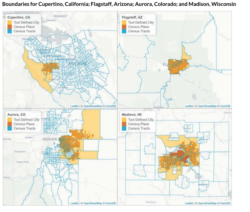
The census analog of a city is a census place, and the census analog of a neighborhood is a census tract. A census place is a concentration of population that has a name, is locally recognized, and is not part of any other place. Census tract boundaries often, but not always, coincide with the boundaries of places. In some cities—particularly small and medium-sized ones—the city boundaries only partially cover some census tracts. This is problematic because the neighborhood-level demographic data our tool uses are available only at the census tract level. Creating a more accurate city definition would require using more granular block- or block group–level data, which would increase computation time and have far larger margins of error for our demographic variables. So, we needed an operational definition of a city that spans whole census tracts.
We decided on the following census tract–based definition for city boundaries: All tracts that had at least 1 percent of their area contained within the place boundary were considered part of that respective city. Because of this overinclusive definition, the tool will think that many cities, particularly small or medium-sized cities and a handful of irregularly shaped large cities, are bigger than they actually are, in both area and population. We decided on this 1 percent overinclusive cutoff for two reasons:
- After visual inspection of a few cities, the 1 percent cutoff gave reasonable results for city boundaries.
- The 1 percent cutoff allowed us to exclude tracts on the border of census places. If we imposed no cutoff (i.e., we defined a city as all tracts contained even partially within the place boundary), then the city definitions would include tracts that shared a small portion of the border and the cities would be much larger than expected.
To visualize how this definition affects small and medium-sized cities, consider figure 1. We can see that small cities such as Cupertino, California, and Aurora, Colorado, have irregular place boundaries that partially overlap a few census tracts. As a result, the area of the cities as defined by our tool (in yellow) is greater than the actual area of the cities (in orange).

County, State, and United States Boundaries
We define the county, state, and US boundaries using the TIGRIS/Line boundary shapefiles that align with the end year of each five-year ACS dataset used in the tool (2015–2019, 2017–2021, and 2018–2022). Within the census geography hierarchy, tracts always fit cleanly within county, state, and US boundaries. As a result, we can use directly reported county, state, or US estimates from the census for the national-, state-, and county-level tools.
For the city-level tool, we have to derive the comparable city-level estimate from the constituent census tracts, as described in the “City Definition” section above.
The states in our tool include the 50 US states and the District of Columbia. We do not include the US territories in our analysis, as the ACS does not collect data in American Samoa, Guam, Northern Mariana Islands, and the US Virgin Islands and does not report all of the data used in the tool for Puerto Rico. We hope to include US territories in future iterations of the tool.
